I started playing a game called GeoGuessr in February 2021 when I came across a YouTube video. I always had an avid interest in geography, so I was genuinely surprised I hadn’t come across the game any earlier. Basically, the game involves guessing the location of a place based on the Street View that you are shown. The objective is simple but the logic that is used in guessing the location is quite complicated. New players can quickly get overwhelmed by the number of different inputs they receive by viewing a single frame of Street View. The following are some aspects that can go into guessing a location:
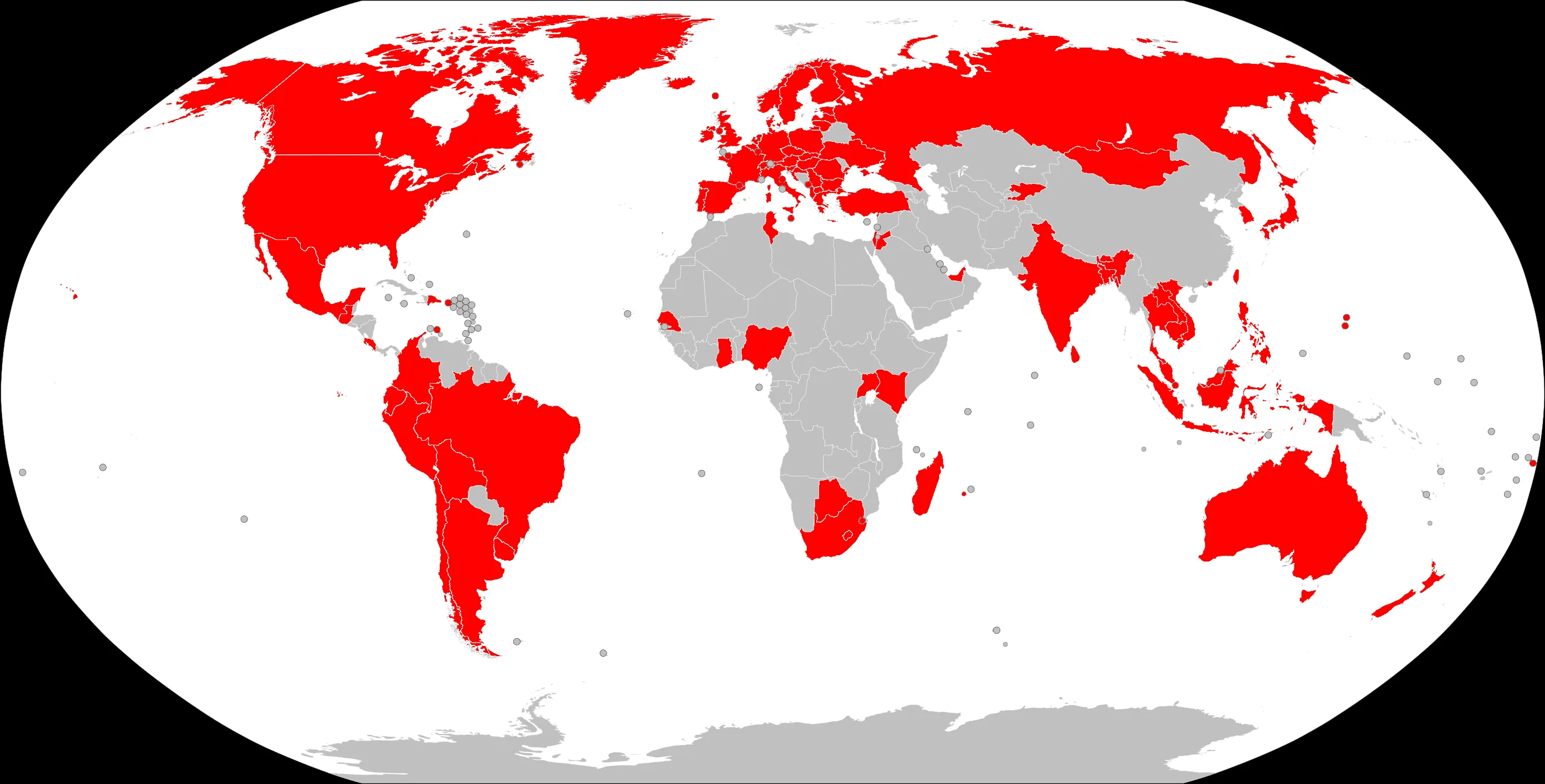
- Countries available in Street View (currently 104, see image below)
- Driving direction
- Language script
- Structure of words and names (linguistics)
- License plates
- Street signs
- Terrain
- Flora
- Weather
- Car and camera equipment used for mapping the streets (metagame, frowned upon)
I learned a lot about driving, street signs, license plates, terrain, and flora through different online guides and YouTube videos. However, I wasn’t able to find comprehensive guides to understand differences between language scripts (especially different Latin-based scripts and Cyrillic-based scripts). I had to look at the entire scripts of the languages through Wikipedia and other resources.
The new game
I decided that better language-oriented GeoGuessr resources are needed and came up with the idea of a learning game: Geo City Learner. The game helps learn what city names can be associated with what countries based on the languages spoken in the countries, and the scripts and letter patterns used in those languages.
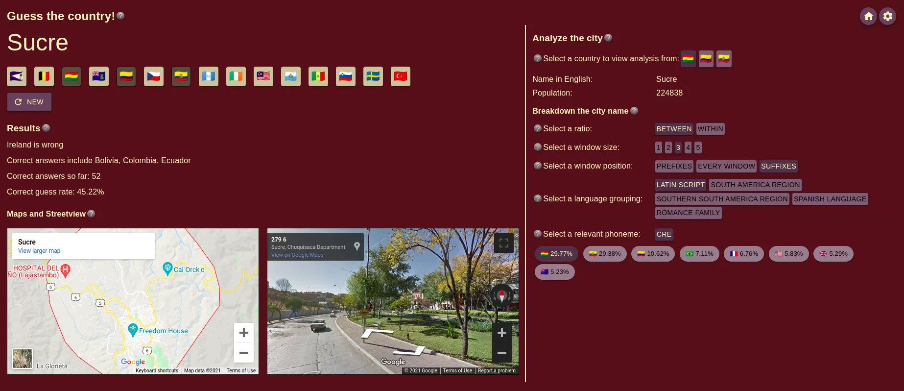
How the game works is simple. A city name is displayed to the player. They need to guess what country the city is located in (could be multiple right answers). Once the player guesses, they receive a summary of their guess, details about the city, and Google Map and Street View of the city’s location in the world. Most importantly, through the game, I provide probabilistic information based on the phonemes used in the city names. New players can benefit from simple information such as what letters are present in what languages, while veterans can take it a step further and learn digrams, trigrams, prefixes, and suffixes etc.
Data
I generated the data in two steps. I used an opendatasoft database of city names from the 104 countries that are available in Street View. This dataset was not fully clean and was missing the population for some cities. It also did not have a clear pattern for the city names translated to other languages. It also often did not have the translation of the city name available in the native language(s) of the country.
I cleaned the dataset and used Google Translate’s API to translate the names into their native languages. I would have preferred using a transliteration API instead but unfortunately Google abandoned their Input Tools development leaving it with a very limited choice of languages. The translation was often broken or translated incorrectly when the API mistook proper nouns (cities) for common nouns with the same or a similar spelling. I fixed the broken translations manually, but a fix for the incorrect translation is a job for the future that I might have to crowdsource since there are close to a 100,000 cities in my final dataset.
Development
I spent a lot of initial time on the data to decide whether the project is viable or not. Once I decided it was, I had to work on deciding a suitable architecture for creating a website, storing the data, and hosting the website. In fact, some of my development process for the project is mentioned in a blog post of mine.
I chose to store and load the data into a backend server as JSONs after using a database such as Google Cloud Firestore proved to be too slow for my purposes. The backend server is written in Python Flask and performs any computations and transformations of the data. A lot of data is cached during a slow start to allow faster server times overall even though the first request may take longer. This server is hosted on Google Cloud Run.
The frontend for the website is designed with ReactJS and Material UI. The static webpages are served using a Node.js + Express.js server that acts as a middleware to glue the actual backend server with the frontend. This server allows for some basic authentication involving cookies and AES-encrypted tokens. This authentication is not to necessarily establish a user or secure the API, but rather to discourage cheating and free use of the backend API.
Further development
There is still a ways to go. I will be releasing the game on the r/geoguessr subreddit to receive feedback on what improvements can be made to the game to make it more viable. Some ideas I currently have floating in the back of my head include:
- Personalizing the cities that are displayed for guessing based on how often the user incorrectly guesses a country.
- Adding multiple languages per country. Currently, I have limited each country to be associated with a single language which is wildly incorrect.
- Add a potential log-in system.